Suðurnámur
Hiking
Southern Region
63.991712,-19.058792
4X4
~2 hours
-
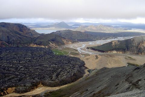
Suðurnámur is a striking mountain range located in the Icelandic Highlands. This location is renowned for its vivid rhyolite cliffs, which display a rainbow of colors, from deep reds and oranges to bright whites and greens – a geological marvel formed over millennia through volcanic activity.
The key features of Suðurnámur that draw visitors are its expansive and diverse geothermal landscapes. The area is famous for its steaming vents, bubbling hot springs, and fumaroles that dot the terrain, offering a rare glimpse into the raw power of Earth's geothermal processes. Hiking trails crisscross the rugged land, providing ample opportunities for adventurers to absorb the otherworldly scenery and the rich geothermal activity beneath their feet.
Located in the Landmannalaugar region, Suðurnámur stands near the Fjallabak Nature Reserve in the central highlands of Iceland. The area is accessible primarily during the summer months due to harsh weather conditions in the winter. A high-clearance 4x4 vehicle is recommended to navigate the challenging mountain roads to reach this remote natural wonder.
Nearby attractions include the vibrant Landmannalaugar geothermal pools, where visitors can indulge in a relaxing soak amidst the colorful rhyolite hills. Additionally, the Laugavegur hiking trail, one of Iceland's most iconic and scenic routes, starts at Landmannalaugar, offering further exploration of the dramatic landscapes that define this remarkable region.
Where is Suðurnámur located?
Download GPX file
Suðurnámur ➤ 63.991712,-19.058792
Attractions near Suðurnámur
Frequently asked questions
Do you need a 4x4 to reach Suðurnámur?
Yes, a 4x4 vehicle is recommended to access Suðurnámur as it is located in the rugged highland terrain of the Landmannalaugar area, which includes challenging gravel roads.
When is the best time to visit Suðurnámur?
The best time to visit Suðurnámur is during the summer months from June to early September. This is when the F-roads to Landmannalaugar are generally open, and hiking conditions are optimal.
What activities can you do at Suðurnámur?
Hiking is the main activity at Suðurnámur. The region offers breathtaking trails with stunning views of the colorful rhyolite mountains. Visitors can also take advantage of the nearby hot springs in Landmannalaugar for a relaxing soak after a hike.
What makes Suðurnámur unique?
Suðurnámur is known for its unique and vibrant landscape, characterized by colorful rhyolite mountains and geothermal activity. This creates a picturesque and varied scenery unlike any other in Iceland.
How long does it take to hike Suðurnámur?
The Suðurnámur hiking trail can typically be completed in about 3 to 4 hours, depending on pace and trail conditions. The route offers panoramic views of the surrounding rhyolite mountains and lava fields.
Are there guided tours available to Suðurnámur?
Yes, several guided tours are available to Suðurnámur, often starting from the Landmannalaugar area. Guides can provide valuable insights into the geology and history of the region.
Is Suðurnámur accessible year-round?
No, Suðurnámur is generally only accessible during the summer when the F-roads are open. Access during other seasons is limited and typically requires specialized vehicles and equipment.


